From earliest dawn of history man has used rivers & lakes for transport. This also applied to Ireland with its lakes and slow running rivers. Unfortunately these left Ireland vulnerable to attack from foreign invaders such as the Vikings and the Danes. The first known use of navigable waters in Ireland was the Battle of Lough Ree when Brian Boru raised a fleet of 300 boats to defeat the Dane Turgesius. More recently, drainage work on the Ulster Blackwater has revealed evidence of ancient settlers, possibly Vikings, who had sailed up one of the rivers, probably the Lower Bann to Lough Neagh and up the Blackwater.
The problem was shallow parts of a river where a dam is required to stem and raise the water level upstream, with a lock to allow the boat raise or lower. The Chinese had a system 2000 years ago using sluice gates, which were very wasteful of water.
The first “Pound Lock” [to impound water] was invented by the Assistant Commissioner of The Grand Canal of China in 983 A.D. This lock used a system of sluice gates, raised and lowered vertically at each end of the lock.
The first pound lock in Europe and the first pound lock, as we know it, using swinging or mitred gates, was in Holland and were invented by the greatest of all inventors, Leonardo da Vinci in 1373.
At first locks were only used to make rivers navigable but soon engineers found a way to raise boats to a high level at a watershed and lower them, provided they had sufficient water. The first of these was the Canal-du-Midi linking the Atlantic Ocean to the Mediterranean in the south of France. It was built between 1661 and 1681 and is still in use.
The first canal built in Ireland was a cutting to connect upper and lower Lough Corrib in the 12th centaury. Some other attempts were made but failed.
The Newry Ship Canal and the Newry Canal
In the early 18th century Dublin developed a demand for coal and was importing some 60,000 to 70,000 tons from England at 18/- per ton.
Ireland was very anti British at the time and one member of the Irish Parliament, the Church of Ireland Dean of St Patrick’s Cathedral, Dublin, Dean Johnathan Swift, advocated “Burn everything British except their coal”. One problem was that all taxes went to England who was happy to return some of this revenue in the form of capital grants. Why buy British coal when they would pay us to mine our own?
Ireland had some coal and still has. The only viable mining areas are Coalisland, Ballycastle, Arigna, and Castlecomar. |
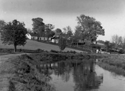
Newry Canal near Poyntzpass |
In 1717, the Irish Parliament offered a reward of £1000 to the first person who produced 500 tons of coal in Dublin. Hugh Boyd of the Ballycastle Colliery who transported the coal down the coast, won the prize and used the prize money to enlarge Ballycastle Harbour. Ballycastle coal was not the answer to Dublin’s problem, as it did not attract grant aid.
After study it was decided to look to the Coalisland area where there were some 12 pits, each with four men, mining 20 tons per week selling locally at 6/- per ton. Transport to Dublin was estimated at 7/6 per ton, making a total cost 13/6 per ton.
It was decided to build a canal from Newry to Lough Neagh and sail the boats down the coast to Dublin.
The canal was to be in two parts.
1 Newry Ship Canal. This was to keep the water level in Newry harbour constant. Originally the locks were just outside the harbour but, in 1769, the ship canal was extended to a point two miles below Newry with new gates 22’0” wide to take 120 ton boats. In 1850 the gates were widened to 32’0” to take boats up to 3,000 tons. The ship canal is still open but seldom used as commercial shipping was moved to Warrenpoint in the 1970s.
2 Newry Canal. This canal was 18½ miles long with 14 locks and went from Newry to the River Bann just upstream of Portadown where the boats could be sailed or towed to Lough Neagh. Work started in 1741 and was completed in 1742 at a cost of £52,000. It was moderately successful and closed in 1939. The line of the canal is intact but the canal is derelict and the four swing bridges in Newry have been made solid. Newry Canal was the first summit canal in the British Isles
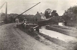
Harbour Poyntzpass |
Some coal did reach Dublin but very little. One record refers to the “Cope” delivering a load of coal to Dublin on 28th March 1742. The coal had been taken overland to Lough Neagh.
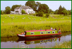
The boats were referred to as “Lighters” and were much bigger than ordinary barges. They were 60’0” long and 13’6” wide and were based on the Thames sailing barge or the “Mersey Flat”, which could and did sail off shore.
|
The Coalisland Canal and the Tyrone Navigation
Once the rejoicing at the arrival of the two boatloads of coal in Dublin had subsided it was realised that the cost was far too high. The cost of cartage from the mine at Coalisland to Lough Neagh was higher than the cost of the rest of the journey to Dublin and the total cost far exceeded that of shipping coal from England.
A proposal to build a canal from Coalisland to Lough Neagh had been agreed and the work had started in 1732 under the patronage of The Church of Ireland Archbishop of Armagh and under the supervision of one of his curates “Pastor Johnston”. The poor man had no engineering skills and the job was extremely difficult with the Lough Neagh marshes and the feeder river, the Torrent, running alongside causing constant leaks.
The canal was eventually finished in 1787 after 55 years. It was four miles long with
seven locks, which were the same size as those on the Newry Canal, 66’0” long by 14’6” wide.
Some said the delay was due to gross inefficiency while others said it was to make continuing use of the grant money, which was pouring in. Between 1753 & 1767 a total of £118,200 was paid out to the mining projects out of a total budget of £640,358 for all the capital works in Ireland over the 15-year period. The locals may have feared that this grant money would dry up if the project was completed and coal started to flow to Dublin.
Problems still arose in Coalisland. Of the four mines, the two near Dungannon were by far the most productive but were three miles from the canal. By 1762 no coal was reaching Dublin, which was now importing some 180,000 tons of coal per year, so it was decided to extend the Coalisland Canal to the Drumglass pits near Dungannon, a distance of three miles.
The problem was level as the Drumglass pits were 200ft above Coalisland. A rise of 200ft would require 28 locks and would be totally impracticable.
A French Architect/Engineer, Daviso de Arcort [Referred to as Ducart] came up with the idea of inclined planes, or “Dry Hurries” which had been used successfully at Iron Bridge to connect the Shropshire Canal to the Coalport Canal. The idea was to have a sloped incline with railway lines where the boat could pass down the hill on a cradle. The boat going downhill pulled another boat uphill controlled by a winch, in this case a horse gin. Here it was ideal as all the traffic was downhill. There were three hurries, one 65ft rise, one 55ft rise and one 70ft rise, a total of 190ft rise. Between each rise would run a level stretch of canal. The boats were “tubs” which were 10ft x 4ft and sailed between hurries on larger boats.
We do not know when work stared but it was well in hand by 1767 and was complete in 1773, 14 years before the Coalisland Canal was complete. In 1789 a bill was introduced to promote the linen industry on the borders of Lough Neagh and a thriving linen industry grew up round Dungannon using all the Drumglass coal. Ducart’s canal was not required and never used except to prove that it could and did work, even with difficulty, but did work well enough to collect the grant money. The canal was partly filled in as early as 1837.
By 1790 a thriving linen industry was springing up in Dungannon and Coalisland, which lasted until some 10 years ago with the demise of Moygashel. Coalisland developed a thriving clay industry, which survives to this day.
Dublin got two boatloads of coal, possibly a few more but these are not recorded. However east Tyrone got an industrial base which earned it the name “The Black Country of Northern Ireland.”
The canal basin in Coalisland has been filled in, with car parking and a new road on it but the remaining part of the canal is virtually intact though derelict. There is no likelihood of it reopening.
Two of Ducart’s Hurries still exist, one in remarkably good condition, together with an aquaduct where the canal crossed the Torrent River, built in 1760. Two short stretches of the canal still exist.
In Coalisland an old flourmill has been restored as a community centre. A very interesting display on Industrial Coalisland is on view including that of a small mine and a display showing how a “Dry Hurry” worked.
When Ducart was in Coalisland he built himself a house whish still exists. He also designed and built a number of other buildings in Ireland, one of the most famous is the old Custom House in Limerick City, now The Hunt Museum.
The Lagan Canal
The success of the Newry Canal proved the use of Lough Neagh as a focal point for inland waterways in Northern Ireland and consideration was made to connect Belfast and Lough Neagh by water, again to tap the supply of Coalisland coal.
Work started in 1756 and Lisburn was reached in 1763 with the first boat, “The Lord Hertford” carrying a load of English coal to Lisburn. The canal reached Lough Neagh in 1793 and was opened for business in 1794.
The canal ran from Annandale Embankment to Ellis Gut at S.E. Lough Neagh. It was 27 ¾ miles long with 27 locks reach 66’0” x 14’6” the same as the Newry and the Coalisland canals allowing free movement of lighters over the whole system.
Lagan Canal |
Lighters were first sailed across Lough Neagh but in 1821 the Navigation Co. built a tug “The Marchioness of Donegal”. No details of it are available but it was probably similar to the “Charlotte Dundas” the first steam tug on the Clyde which could tow two boats 70 tons each, similar to the Coalisland lighters. It was replaced by a series of tugs which operated until the system closed in 1947.
This was a marvellous asset to East Tyrone who now had a system of transporting the goods produced in the industries set up, using the grant money from Dublin. Lighters from East Tyrone could deliver and collect goods to Lough Neagh, Newry port, Belfast and the Lower Bann to Coleraine. Lighters could and did sail to Scotland and northern England. |
The Lagan Canal and the Coalisland canal were the last canals in Northern Ireland to close, which they did in 1947.
The Lagan canal is reasonably intact as far as Lisburn, with two sets of locks beautifully restored in Lisburn beside the council offices. The motorway is built on the line of the old canal from Sprucefield to Moira from where the canal is intact as far as Lough Neagh. There is no possibility of this reopening as the motorway is on the line of the old canal. Between the Sprucefield junction and Moira two old warehouses can be seen alongside the motorway.
The Ulster Canal
By the early 1800’s the success of the three canals centred on Lough Neagh was very evident. The Grand and Royal Canals connected the River Shannon to Dublin. The Grand Canal was connected to Waterford and the south by The Barrow system. This left the River Shannon as a hub for inland waterways in the south of Ireland just as Lough Neagh was the hub for the north of Ireland. It was felt that the two systems should be connected.
| The first stage was to connect Lough Neagh to Lough Erne and investigations commenced in 1814. The barges on the Grand Canal were narrower than those on the Lough Neagh system at 12’3” and those on the Royal Canal were 12’ 6”. The reason for this was the water supply. The Lighters required 500,000 gallons of water to fill a lock. This was all right on the three canals based on Lough Neagh as water was plentiful but in the lowlands of central Ireland it was a different story. A decision to use 11’6” boats was taken; these would require 350,000 gallons of water to fill a lock. |
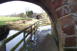
Wattle Bridge on the
Ulster Canal |
The canal commenced at Charlemount on the river Blackwater a couple of miles above the Coalisland canal. It rose by 19 locks to a summit at Monaghan town and fell a total of seven locks to join the Erne at Wattle Bridge, a total of 47 ¾ miles. Work commenced in 1825 and was completed in 1841.
This canal was never a commercial success as the narrow boats proved to be a disaster. They could ply the whole system but the lighters could not use this canal; transhipment was the order of the day and was very expensive.
A second, and much more serious problem was water shortage. The summit was at Monaghan town, a flat plain, where water was in short supply even for the narrow lock, leaving the canal closed for as much as six weeks in a dry summer.
Trade was negligible and the company went bankrupt in 1865. The Board of Works took it over and reopened it in 1873. The railway arrived in Monaghan in 1858 and Clones in 1863. After this only a few boats plied the canal and its most useful purpose was to be an alternative to the railway and keep their rates competitive. The canal closed in1929 and was officially abandoned in 1931.
Very little of the canal still exists. Some of the lock houses are preserved and some of the warehouses are still in use. About one third of the canal bed exists but the remainder has been excavated and returned to farmland. A lock and lock house have been restored at The Benburb Cultural Centre.
Following the reopening of the Ballinamore canal to form “The Shannon Erne Waterway”, in May 1994, a campaign was launched to reopen the Ulster Canal. This reached a climax in 2000 when a feasibility study was carried out and a draft scheme prepared with an estimated cost of £90,000,000, three times the cost of the Shannon Erne scheme. The big problem will be land purchase as compulsory-purchasing orders may not be available. This has sounded the death knell to many proposed preserved railway schemes. In addition to this the final cost could greatly exceed the estimate. However it would greatly enhance the present inland waterways system if this scheme did succeed.
The Ballinamore Canal
The Ulster Canal connected lough Neagh to Lough Erne in 1841 and the next stage was to connect Lough Erne to the Shannon. This was looked at in1838 and a scheme started in 1846 and completed in 1859.
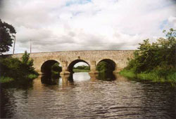
Ballinamore Canal |
A different approach was taken to this scheme than the Ulster Canal. By this time steam had arrived and steamboats were plying the Shannon so it was decided, very wisely, to base this canal on the Shannon rather than the Ulster Canal and used 16’6” locks. It was a total of 38 miles long with 16 locks.
This canal proved to be a complete disaster with two problems. Firstly, it crossed four lakes and only self-propelled boats could use it. Secondly, there was a summit between some of the lakes and, again a very inadequate water supply. |
A total of eight boats are recorded as having used the canal, paying tolls of £18, a poor return for the cost of £276,992.
Only one boat is recorded in detail. The steamer “Knockninney” was sailed from England, up the Shannon through the canal to Lough Erne where it traded for many years. The journey of 36 miles took three weeks.
The opening of The Cavan & Leitrim Railway in1887 removed all thoughts of using the canal, which had been disused since 1869.
However “The Ugly Duckling became The Beautiful Swan”. In the 1960s and 1970s a very thriving tourist industry had developed using leisure cruisers on both the Shannon and the Erne. A feasibility study was carried out in the 1980’s by the two governments as a cross-border community project. The canal had never been abandoned and was intact requiring very major reinstatement rather than a rebuild.
Work commenced in 1991 and the canal was reopened in May 1994, the cost being £30,000,000. It has proved to be by far the most successful venture of its kind in Ireland and probably one of the most successful in Western Europe.
The two problems, which dogged the canal in the mid 1800s, were easily solved. The four lakes can be easily traversed, as all cruisers are self-propelled. The water at summit level between the lakes is not a problem as there is plenty of water in the lakes and large electric pumping stations have been installed to serve each summit.
The Strabane Canal
This canal, which was the only one of importance outside the Lough Neagh system and was built by the Marquis of Hamilton between 1791 and 1796 “To connect the prosperous town of Strabane to the port of Londonderry”. It was four miles long with two locks one at the junction with the River Foyle and one half-way along; one lock was 22’0” wide and the other 23’0” wide. It could and did take ocean-going schooners, up to 300 tons burden, the size of the one depicted in the Folk Park.
In 1836, lighters, manned by two men made 538 journeys making Strabane, with a population of 4700 a flourishing market town. Unfortunately, this was short-lived with the railway reaching Strabane in 1847.
Originally seagoing sailing craft sailed to Strabane but the Carlisle Bridge, opened in 1863 put an end to this even though it had an opening section. The lighters were towed by a steam tug “Shamrock” to the mouth of the canal and on by horse. In the 1920’s a Strabane engineering works and garage fitted engines to the lighters which, self- propelled, continued to use the canal until 1932 when the last lighter sailed
The Bann Navigation and Lough Neagh
The lower Bann has always been a connection between the sea and Lough Neagh, the largest freshwater lake in the British Isles. Some years ago, a drainage scheme was carried out on the River Blackwater and remains, thought to be Viking, were found. There is no way that these people could have reached here other by the Lower Bann and Lough Neagh as tradition says that they did not travel overland.
In 1842 an Act of Parliament was passed “To improve navigation, drainage and mill power in the Lough Neagh basin”. Work started in 1847 and was completed in 1858. This scheme lowered the river, removed rock obstructions, and provided five sets of locks, 130’0 “long, 20’ 0” wide and swing bridges. Lough Neagh now had a third access to the sea.
In the late 1800s and up to the coming of lorry transport in the 1960s it was extensively used for commercial traffic, the last being sand for shipping at Coleraine using the old Guinness steam barges.
The Bann navigation is open and the Cruiser “Maid of Antrim” occasionally sails from Lough Neagh to Coleraine and the open sea. Responsibility for its upkeep has recently been transferred from to the rivers section of the Department of Agriculture to the newly formed “Waterways Ireland” with a view to promoting its use for pleasure craft.
One of the unique features of the Lough Neagh navigation was the two ferries crossing the river Blackwater and the Upper Bann. They operated until the early 1970s. A new footbridge was erected recently at Maghery on the site of the old ferry as a community project.
Lough Neagh was always used for navigation and still is. In addition to the “Marchioness of Donegall” and her successors towing lighters and iron paddle steamer “Countess of Caledon” plied the lough. Many boats have plied the various harbours since. Lough Neagh is now used extensively used for pleasure craft and is an excellent sailing lake.
The Erne Navigation
Since time known Lough Erne has been used for navigation though the first written record of this is in 1830 and refers to “Cotts which are square ended and flat bottomed boats, rigged with a gaff sail and carrying a burden of 10 tons”. Similar boats are used today to move livestock to and from the islands, driven by outboard motors.
Different pleasure craft plied the lake including the “Knockninney” which had sailed through the Ballinamore Canal. The best known was the “Lady of the Lake” which traded until 1915. Its main duties were cruises to and from Castlecaldwell in conjunction with the railway.
Lough Erne is landlocked apart from the canal in the south leading to the River Shannon and the sea at Limerick. An attempt was made in 1778 to build a channel from Belleek to Ballyshannon but failed due to the hardness of the rock and was not attempted again.
Lough Erne is today used as a cruising lake, one of the most successful in Europe.
Canal people
Canal people were a unique band of men and woman and were divided in three groups.
1. The Bargees: These men both owned and traded their own boats or “skippered” a boat for its owner. They lived on the boat and were sometimes married with a wife and family who lived aboard. In a way their lifestyle was similar to traveling people today except that they were waged.
2. The Hauliers: These men owned their own horse and towed whatever boat required towing for a fee. They were regarded as outcasts by the bargees and were not allowed onboard as they always had horse fleas. They slept overnight in a shed at the locks, as the lockkeepers did not want fleas either.
3. The lockkeepers: Lockkeeping was a family affair with the job passing from father to son and in some cases a daughter. It was usual to name the lock after the lockkeeper.
Top |